Did you know?
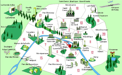
The map of Paris shows the 20 different neighborhoods which are called arrondissements. In Paris arrondissements are named according to their number. For example, you might live in the 5th arrondissement, which would be written as 5eme (or 5e) in French. Looking at the Paris Map you can see that the districts spiral out from the center in numerical order. If you know the postal code of any address in Paris, you can easily identity which arrondissement it is located in because Parisian postal codes take the form of -75XXX-with the last two digits being equal to the arrondissement (e.g. 75008 is the postal code for the 8th arrondissement). The suburbs are called the banlieues. The areas to the west of the city ( Neuilly, Boulogne, Saint Cloud, Levallois, Versailles) are the most desirable and they are generally more peaceful than the city.